


By GARTH SAMPSON, South African Weather Service
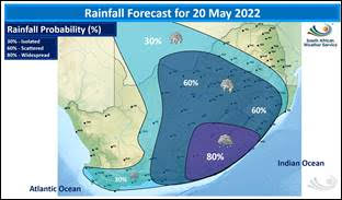
A steep upper-air trough system will develop into a cut-off low-pressure system over the north-western interior of the country by Friday, 20 May. Widespread rainfall can be expected over the southern and central parts of the country from Thursday onwards, with light snowfalls likely over the mountainous, high-lying areas of the Western and Eastern Cape, spreading to the Lesotho Drakensberg regions by the weekend, where heavier falls are anticipated.
24-hour rainfall accumulations of 25 to 35 mm can also be expected over the drought-stricken parts of the Eastern Cape, including Makhanda.

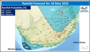

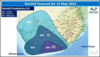


A cold front will move over the southwest coast of the Western Cape by Wednesday afternoon, with rain spreading along the south coast and adjacent interior in the evening. The upper-air trough will intensify on Thursday, causing widespread rainfall over the eastern parts of the Western Cape and the western parts of the Eastern Cape. A yellow level 2 warning for disruptive rain, resulting in localised flooding of susceptible roads and bridges and flooding in informal settlements, can therefore be expected in the areas mentioned above, spreading to the central and south-eastern parts of the Eastern Cape during Thursday.
Due to the lowering of atmospheric freezing levels, combined with abundant moisture in the lower layers of the atmosphere, snowfalls as deep as 2 to 5 cm can be expected from Thursday night over the eastern high-lying areas of the Western Cape, spreading to the western high lying areas of the Eastern Cape. Heavier snowfall of 10 to 20 cm can be expected over the north-eastern high ground of the Eastern Cape, the Drakensberg region of KwaZulu-Natal and the Lesotho mountains from Friday evening into Saturday morning.
Thunderstorms, combined with strong, gusty surface winds, are expected over the central interior by Friday afternoon, spreading to Gauteng, Mpumalanga and KwaZulu-Natal in the evening and parts of Limpopo by Saturday. Warnings in this regard will be issued if necessary. Due to the pre-existing condition of water-saturated soils in parts of KwaZulu-Natal, rainfall amounts exceeding 20 mm are likely to lead to localised flooding. Therefore, communities need to take precautions to prepare for such conditions.
Bitterly cold conditions are expected to move over the western and southern parts of the country on Thursday, spreading to the central and eastern parts by Friday and Saturday. Maximum temperatures are not expected to exceed 14°C over the country’s interior, with maximum temperatures barely able to reach 8°C over the high-lying areas of the Eastern Cape. Small stock farmers should be advised of these conditions and take the necessary precautions.

