


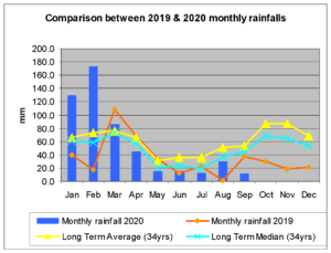
Well it didn’t turn out like I expected, it is the fourth lowest rainfall for September in 35 years of monitoring: only 10.7mm for the month.
There have been similar circumstances in the past, where September rainfall has been exceptionally low. While the Long Term Average is at 52.9mm and the Long Term Median is 45.0mm, these are:
1996 (12.3mm), 2007 (9.9mm), 2011 (2.2mm) and 2003 (1.4mm). The rainfall bounced back in October in 1996 (73.2mm), 2007 (59.8mm), 2011 (101.4mm) and 2013 (140.3mm).
This is what we need: buckets of rainfall to replenish our dams.
The rainfall we received this September occurred over two rain days at the beginning of the month and another two at the end of the month, only just qualifying. The Ocean Nina Index (ONI) has however continued to decline. Now, in June/July/August it is at -0.4.
The ONI is a running three-month mean sea surface temperature anomaly. The lowest rainfall recorded at Darling Street for September over the monitoring period 1986 to 2020 was 1.4mm, the highest 170.8mm. The ranges for the rainfall occurrence are 0 to 25mm – 25.71%, 25 to 50mm – 34.29%, 50 to 75mm – 22.86% and above 75mm – 17.14%

Some interesting statistics:
The last time we had in excess of 50mm over a 24-hour period was back in 2015 with 75mm. Total rainfall for the period June to September (winter) 2020 was a meagre 66.3mm.
Other very dry winters were 1995 with 67.3mm and 1996 with 60.6mm. If one wants to be finicky, the rainfall from the Winter Solstice to the Spring Equinox was 61.8mm. So far this year we’ve had 103mm more than in 2019.
I hope in the next three months this can be increased to 200 to 250mm.

