


UPDATE THURSDAY MORNING – All from South African Weather Service
WARNINGS
09/07/2020: Gale force NW winds of at least 62km/h are expected in placed over the interior, including Willowmore, Graaff-Reinet, Cradock, Somerset east, Grahamstown, Fort Beaufort, Enoch Mgijima LM and in places over Senqu LM.
09-10/07/2020: Extremely high fire danger conditions are expected over the Sarah Baartman, Amathole, Chris Hani and Joe Gqabi DM’s as well as Buffalo City Metro today, but over Joe Gqabi and Chris Hani DM’s as well as Dr Beyers Naude and Blue Crane Route LM’s tomorrow.
WATCH
10/07/2020: Strong to gale force NW winds are expected in places over the interior.
SPECIAL WEATHER ADVISORY
11/07/2020: Snowfalls are expected over high lying areas of the province on Saturday. At the moment the chance of snowfall is on Saturday, accumulations are still on the light side. We’ll update should there be any changes expected.
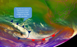

South Africans, particularly the residents of the Eastern Cape and Western Cape can expect chilly, windy and wet conditions in the days ahead as a well-developed cold front makes landfall over the south-western parts of the country on Thursday morning, 9 July 2020, followed by a second cold front shortly thereafter. This report from The South African Weather Service (SAWS).
Localised flooding, gale force winds and high sea conditions are some of the extreme winter weather phenomena we can expect from this system. While snowfalls can be expected over the higher mountains of the Cape provinces, numeric prediction models strongly suggest that such falls will mostly be of a light, non-disruptive nature.
A cold front, expected to make landfall over the south-western parts of the Western Cape on Thursday morning, will result in strong to gale force (60-75 km/h) pre-frontal north-westerly winds over the Western, Northern and Eastern Cape Provinces as well as along the coast between Cape Columbine and Cape Agulhas, spreading to Plettenberg Bay by evening. High seas with wave heights of 6 to 8 m are expected along the coast between Hondeklip Bay and Cape Agulhas on Thursday, spreading to Port Alfred on Friday,10 July 2020 into Saturday, 11 July 2020.
Heavy rain is also expected to set in over the high lying areas of the south-western parts of the Western Cape from Thursday, 9 July 2020, leading to possible localised flooding over the Cape Metropole, the mountainous areas of Cape Winelands and Overberg from Friday, 10 July 2020 into Saturday, 11 July 2020.
Very cold conditions will set in over the Western Cape and the southern high grounds of the Northern Cape from Friday, 10 July 2020, spreading eastwards on Saturday,11 July 2020, with light, non-disruptive snowfalls expected on the mountainous areas of the Western Cape and southern high grounds of the Northern Cape, spreading to the high grounds of the Eastern Cape and Lesotho from Saturday morning, 11 July 2020, into Sunday, 12 July 2020, afternoon.
A significant drop in daytime temperatures will be experienced over the remainder of the interior on Saturday, 11 July 2020, as this frontal system moves eastwards and exits the country along the north coast of KwaZulu-Natal by Sunday, 12 July 2020, with isolated to scattered rain and showers spreading over KwaZulu-Natal.
The main impacts associated with these adverse weather conditions are as follows:
Gale force winds along the coast may result in damage to coastal infrastructure and beach erosion. Disruption to Port and small harbour activities can be expected. Medium to large vessels may be at risk as a result of dragging of anchors. Rough to choppy seas could lead to small to medium vessels experiencing navigation difficulty and being at risk of capsizing and/or “taking in water”. Moreover, rock and surf anglers and general beachgoers are at risk of being swept into the sea by wave and surf action.
Gale force winds over the interior could lead to damage of formal and informal settlements. Trees toppled by strong winds (especially in the Western Cape), can cause damage to property and infrastructure (cars, houses, power lines, roadways) and locally impair or impede smooth traffic flow. Increased travel time is likely and high-sided, articulated trucks are at risk of toppling over as a result of strong, gusty crosswinds, particularly on the N1, N2, N7 and R60.
Strong north-westerly winds over much of the southern and central interior of the country will lead to a widespread risk of runaway fires during Thursday and Friday. Dry air, combined with abundant late winter grassland fuel is likely to exacerbate this seasonal late winter risk.
The effects of the cold frontal systems are also expected to be seen in the general sea state, with high to very high seas with waves heights between 6-8 m expected between Cape Columbine and Cape Agulhas on Thursday afternoon into the evening, subsiding partially from Friday morning but picking up during late Friday evening between Alexander Bay and Cape Agulhas into early Saturday morning.
Heavy rain is likely to lead to localised flooding of roads, formal and informal settlements which may lead to damage of property and displacement of vulnerable communities. There is also significant potential risk posed by fast-moving streams and rivers and the general public (especially pedestrians and motorists) are strongly urged not to try to cross flooded rivers, waterways and low-water bridges under such circumstances. Localised traffic disruptions are highly likely, together with the associated risk of vehicular accidents. Vulnerable areas are likely to experience disruption to essential services.
Snowfall, albeit mostly of a light nature, may result in localised traffic disruption due to icy roads and railway lines at higher elevations. Some minor inaccessibility could occur for drinking water to rural areas. Farmers of small stock are strongly urged to lead animals to adequate shelter well before inclement weather sets in, to ensure that potential stock losses are avoided or mitigated in icy, snowy conditions at higher altitudes and in the mountains of affected provinces.
The South African Weather Service (SAWS) will continue to monitor any further developments relating to this weather system and will issue timely subsequent updates as required. Furthermore, the public are urged and encouraged to regularly follow the weather forecasts on television and radio issued by SAWS.
Updated information in this regard will regularly be available at www.weathersa.co.za as well as via the SA Weather Service Twitter account @SAWeatherServic and on the Weather Smart App.
Compiled by: Jacqueline Modika, Lehlohonolo Thobela, Lulama Pheme and Stella Nake.
Edited by: Kevin Rae, Chief Forecaster.

